About KBC North South Trek
Start the iconic 28 days KBC North South Trek, a trek around the third-highest peak in the world. Offering an unmatched combination of nature, stunning Himalaya Kanchenjunga panoramas, indulge of culture. This breathtaking KBC North South trek crosses isolated eastern Nepal.
KBC North South Trek which is off the usual route, tests the soul and offers peaceful valleys and the friendly welcome of many ethnic groups. This extensive guide gives you all the information you need to conquer one of the world’s most breathtaking trekking circuits, from a comprehensive daily itinerary to essential planning advice.

This extensive KBC North South trek, in contrast to shorter routes, offers a wide range of experiences from the cold, high-altitude glacial zones at over 5,000 meters to the subtropical lowlands of the Tamor River. KBC North South trek highlights the Himalaya Kanchenjunga region’s enormous size and biodiversity.
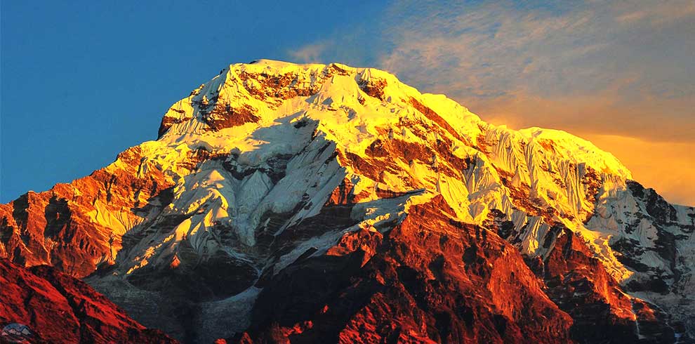
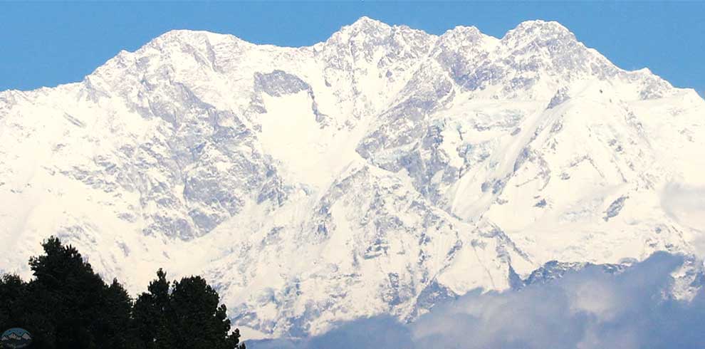
Trekkers can enjoy views of the majestic Mount Kanchenjunga from both its southern (Yalung Glacier) and northern (Pangpema) sides, each of which offers a distinctive and breathtaking view. This walk is characterized by its isolation, necessitating camping arrangements and providing a sense of genuine discovery that is uncommon on many other treks.
Major highlights of KBC North South Trek
- North & South Kanchenjunga Base Camps
- Pangpema (5,143 m) – full north face view
- Yalung Glacier & South Base Camp
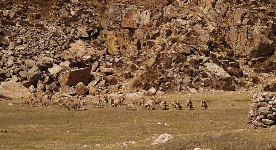
- Rare wildlife: marmots & blue sheep
- Spring rhododendron forests
- Kanchenjunga, Jannu, Kabru & Rathong views
- Wild, isolated Himalayan trekking experience
- Remote valleys: Kambachen & Lhonak
Cost of KBC North South Trek
| S.No. | Luxury | All Incl | Service | |
| 1 | Cost (in USD $) Details | |||
| 2 | Licensed Guide | √ | √ | √ |
| 3 | Accommodation during trek | Standard | Private | × |
| 4 | Transportation to trek start point | Private | Shared | Shared |
| 5 | Shower | √ | √ | √ |
| 6 | Airport/bus terminal Shuttle service | Private | Private | × |
| 7 | Hotel at KTM | 5 Star | × | × |
| 8 | Food on trek (BLD) | Unlimited Meal | 3 Meal | × |
| 9 | Desert | From Menu | Fresh Fruit | × |
| 10 | Soft drink | unlimited | 1 | × |
| 11 | Porter | Private | Shared | × |
| 12 | Company Cap & T-shirt | √ | √ | × |
| 13 | Dawn Jacket & Sleeping – bag to be returned | √ | √ | × |
| 14 | Hard drink | Local Brand | × | × |
| 15 | Warm up hike | √ | × | × |
| 16 | Farewell party/dinner | √ | × | × |
| 17 | Buffer day for trek | √ | × | × |
| 18 | Food in the city | × | × | × |
Cost Details of KBC North Southh Trek-General Inclusions
- Airport pickup and drop by private car or micro bus (Depending on group Size)
- Hotel in Kathmandu (according to the itinerary & the plan you choose to go with), B/B (bed and breakfast)
- All your meals (Breakfast with tea, Lunch and Dinner) during the Trekking.
- Fresh fruit will be served every night.
- All accommodations during the trek.
- All necessary paper works, special entry Trekking permit for Kanchenjunga (restricted trek trail permit)& Trekker`s information management system (TIMS).
- Fluent English speaking and trained, Government license holder guide including all his salary, food, drinks, accommodation, transport and insurance during the trekking.
- A Strong, helpful porter with proper equipment, Food, Accommodation, Insurance (one porter for two people), if u need.
- Credit card processing fees for online payment.
- Added Value - (1) Dawn sleeping bag, Dawn Jacket to be returned after the trek (2) Waterproof duffel Bag, Walking Poles, quick dry T-shirt, Cap - to take away (3) Oxymeter to check your oxygen saturation and Heart beat with medical kit box carried by Guide (4) Satellite Phone for extremely remote destination
Cost Details of KBC North South Trek-General Exclusions
- Nepal entry visa fee (you may easily issue the visa upon your arrival at International Airport - Kathmandu). You need 30$ dollar visa fee for 15 days, cash money will be easier.
- Food while you are in Kathmandu.
- Your Travel and medical insurance.
- All the alcoholic and non alcoholic hot and cold drinks. (except tea in the morning)
- Tips for the guide, porter and driver (Tipping is expected).
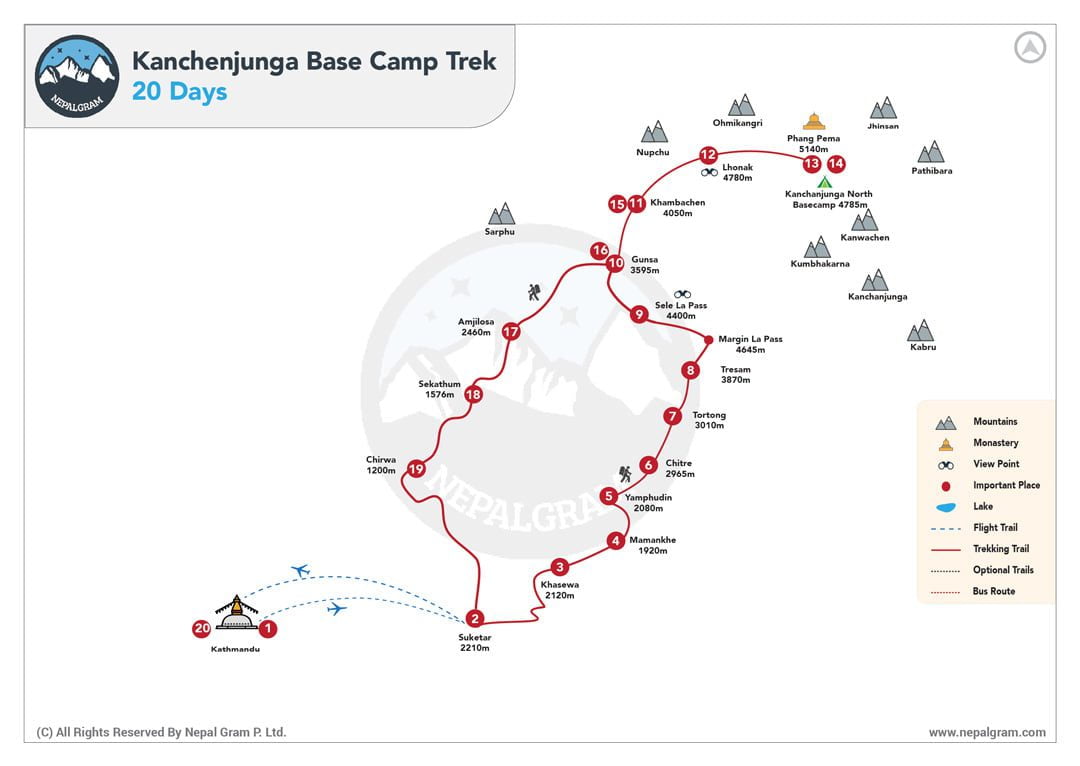
Detailed Itinerary for KBC North South Trek
Nepal welcomes you! When you arrive at Tribhuvan International Airport, a representative will welcome you and take you to your hotel in Kathmandu. Enjoy the opportunity to relax after such a long travel! We'll give you an update on your journey and what to anticipate from the trek this evening.
We take a short (about 50 minutes) flight from Kathmandu to Biratnagar to start the day. After that, we drive to Basantpur, where our trip officially starts. Both parts of the journey are incomparably beautiful: the vehicle drive takes us over an exciting, dangerous mountain road with more than 100 hairpin twists, while the flight provides vistas of our whole trekking trail. The town of Hille will be traversed as we follow the mighty Arun River. At the end of the road, on the ridge above Tanmaya Khola, is Biratnagar. In order to begin trekking early in the morning tomorrow, we will set up camp here for the night.
On this first day of trekking, we will complete roughly seven hours of hiking. Expect to see a lot of other trekkers passing through because the first three kilometers of the trail are shared with main trekking paths that serve the wildly popular Arun and Tamur valleys. After passing Tunde, crowds clear down, and we head to Chainpur, a major shopping post. On our way to Chauki, we will stroll through charming rhododendron forests and tiny towns with breathtaking views of Mount Makalu and Kanchenjunga.
Our trail wanders across the Milke Danda Range, offering us breathtaking views of the mountains of Chamlang, Mera, Makalu, and Kanchenjunga from high points along the route, as well as forests of vividly flowering rhododendron flowers in the spring. Eventually, we will travel to the beautiful town of Gupha Pokhari, where we will set up camp next to a natural pond. We will have plenty of time to explore the village and enjoy our surroundings because we will only be trekking for four hours today.
We have a long day ahead of us, but fortunately it's all downhill. After pausing for lunch in the Gurja Sherpa hamlet, we will travel along the Maihwa Khola and the Tamur Koshi streams to their junction, where we will discover Dobhan's overnight camping location.
Today is the first of three days of trekking through the Tamor Nadi river valley; by the end, we will have ascended about 1,000 metres to reach Sekathum. Due to the monsoon rains, the trail is muddy and soggy as we go into the deep valley. We will trek along the river as it meanders through the bird-filled rainforest! We will have ascended high enough that the road becomes somewhat drier by the time we get at Mitlyng!
Day two of our valley trek continues as we are surrounded by stunning cliffs that intensify the deafening torrent of rushing water in this deep Himalayan river gorge. As we go along the narrow valley, we will pass through patches of dense subtropical forest and observe nearby communities above. Around the time we reach Chirwa, a network of Limbu settlements inhabited by farmers who have been cultivating various grains on the land for thousands of years, the valley finally opens.
We finally get it through the Tamor Nadi valley after five hours of trekking today. Just before Simbuwa Khola, the valley gives path to the Ghunsa River, and we will soon reach Sekathum. A tributary that starts at the Yalung glacier and steadily changing landscape as the valley keeps opening up in front of us mark our goal.
Before we set up camp today, we have a short but steep walk. We will gain about 900 metres in elevation in five hours! When we continue towards Ghunsa, the track becomes substantially narrower, only to widen once more when we approach Amjilassa. As we can see from the homes, attire, and way of life of the natives, we have arrived in the Sherpa and Tibetan region.
Today is a simple trekking day, but a little isolated. We'll be walking through thick forests for four hours, and there won't be any villages in sight. The first village we will come across during the day is Gyabla, where we will set up our camp.
In order to reduce the possibility of altitude sickness, we will walk more slowly as we approach the 3,000-meter elevation threshold. We will walk for five hours to reach Ghunsa, but first we will stop inside the Tibetan village in Phole for lunch. Here, Buddhism flourishes, and a nearby monastery invites us to take a quick break.
Today is the day to relax and rest as we get used to the high altitude we've reached. With lots of opportunities for long, stunning hikes and soaks in hot springs, the Sherpa town of Ghunsa is the perfect place for a day of discovery and tranquilly. Another notable feature of Ghunsa is that it is the final permanent community before north base camp.
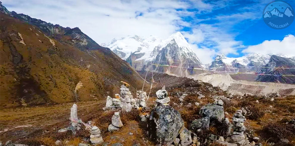
We will be trekking through one of the most magnificent glacier valleys in Nepal, if not the whole Himalayas, over the course of the next three days. From Lhonak, we begin the day on the moraine, and we finish at the foot of Jannu Glacier. We will have a direct view of Jannu and the Kanchenjunga massif from this location. As far as trekking paths go, this is off the beaten path. Because of its remote location, we have a high chance of seeing a variety of wildlife, including smaller creatures like hyrax and marmots, blue sheep, ibex, and mountain goats, as well as raptors like eagles, kites, and falcons.
At this high altitude, with the glacial scenery and no nearby towns or homes, the landscape appears barren and bleak. The trail climbs steadily but slowly; we are somewhat slowed down by the high altitude and moraine debris. The trail circles the north side of the glacier, which starts around Ramtangat. We'll set our camp at Lhonak, where the Lhonak and Kanchenjunga glaciers meet, and take in the breathtaking views of the surrounding mountains.
We set out today to explore the Pangpema area of Kanchenjunga's north base camp, which sees very few trekkers. As a result, the going is difficult and there is no clear path! We'll do as much exploring as we can in the glacial region before setting up camp to recover and stay warm.
The same terrain that took us two days to ascent can be covered in seven hours by going downhill from PangPema! Retracing the route to Ghunsa gives us to see things from a different angle.
Today, as we go out from Ghunsa, dense trees of birch, pine, and rhododendron—possibly covered in snow—line our upward route. We'll walk six hours following the paths folks take to get supplies and get around.
This is a difficult part of our journey! The 800-meter ascent to Mirgin La Pass will reward our perseverance with expansive vistas of the Jannu Himal, Mount Makalu, Baruntse, Chamlang Kabru, and Kanchenjunga. After crossing steep slopes, we will eventually descend to Tseram. We'll walk for eight hours in total.
Today, we start early in order to get to Ramche and set up camp. We'll travel back to Yalung Glacier after lunch. This is a strenuous but manageable climb which is only 7 km away and has a 300 m elevation rise. We will be in wonder of the stunning natural amphitheatre created by the mountains of Rohtang and Kabru on the boundary between Nepal and Sikkim at the glacier.
Today, we have seven hours of relaxing walking ahead of us as we make our way to Tortong via the Simbua Khola, passing through rhododendron and pine forests.
Today's seven-hour hike is hazardous and challenging because this section of the route is risk of landslides. We will be relieved to camp at Yamphudim tonight because we also have to deal with the 600-meter ascent to the Lamite pass at 3,500 metres.
Today's trip will take us across two passes and past the picturesque villages of Brahmins and Chhetri. It will take us about seven hours to walk.
With a steep 1,000-meter descent spanning barely 6 kilometers, our final trekking day is lengthy. After lunch in Dobhan, we'll hike a further 8 metres down a winding but fortunately easy path to the settlement. This is the final "long" day of the trip, with seven hours of trekking!
We climb 1,200 metres to Tharpu in four hours to complete our trek. Now is the moment to relish your last mountain sunset and take in your last views of the Kanchenjunga range, which you have just conquered. It's been a long, thrilling journey. After spending so much time with your guides and trekking partners over the past three weeks, now is the time to celebrate.
Although Bhadrapur airport is only 190 kilometers from Tharpu, the trip will take us nine hours. You might wonder why. Our route passes through at least seven tiny ranges, and the 100 hairpin twists from our first trip resurface. As a result, the driver's average speed is below 30 km/h! Although the journey is exhausting, it is rewarding because you can truly appreciate the intricacy of the terrain we have traversed over the past few weeks.
You have the remainder of the afternoon to rest, unwind, or explore the city after our short flight from Bhadrapur back to Kathmandu. Shop, eat, or just get lost in the strange but friendly bustle of one of the most distinctive and historic cities on Earth.
One of the most significant historical and spiritual sites in the world is Kathmandu. As part of a full day of sightseeing, we will see some of the city's more UNESCO-listed sites than any other place in the world. In addition to the "monkey temple" of Swayambhunath and the revered Hindu temple of Pashupatinath, we will travel to Boudhanath, the largest Buddhist stupa in the world. The well-known and historic Durbar Square will also be visible. We will be hosting a farewell meal at a great Nepalese cuisine in town tonight to celebrate an incredible trip.
Today, as our journey together comes to an end, we bid you farewell. We'll drive you to the airport or just bid you farewell so you may embark on your next journey. Don't forget to exchange email addresses with other tour participants! Please feel free to provide your opinions about the trekking experience; we always value your input.
Including trekking, acclimatization days, domestic flights, vehicle transfers, and sightseeing in Kathmandu, the KBC North South Trek usually takes 26 to 28 days. It is one of Nepal’s longest and most engaging trekking routes, lasting about 24 days.
At 5,143 metres above sea level, Pangpema (North Base Camp) is the trek’s highest point. At around 4,700 metres, the walk also reaches Yalung Glacier (South Base Camp), which offers breathtaking views of Mount Kanchenjunga and neighboring peaks.
The Kanchenjunga Base Camp Trek is regarded as difficult to demanding. Long hiking days, difficult climbs and descents, high mountain passes, glacier terrain, and extended exposure to high altitude are all part of it. Experienced hikers with exceptional physical fitness are the ideal candidates for this expedition.
No, beginners should not attempt the Kanchenjunga Base Camp Trek. It is highly suggested to have prior high-altitude trekking expertise because to its great remoteness, length, camping-based arrangements, and altitude above 5,000 metres.
KBC North South trek is essentially a camping trek with full support. Although there are simple lodges in the lower settlements, the majority of the route—particularly in the vicinity of both base camps—requires camping, making it a true adventure journey.
Two permits are required for trekkers:
Kanchenjunga Conservation Area Permit (KCAP)
Restricted Area Permit (RAP).
Independent trekking is prohibited, and these permits must be obtained from a licensed trekking organization.
Autumn (late September to November) is the ideal season to hike to Kanchenjunga Base Camp because of the clear skies and consistent weather. The second-best season, spring (March to May), is characterized by temperate temperatures and rhododendron flowers.
Particularly in Ghunsa, the timetable includes acclimatization through progressive altitude gain and scheduled rest days. The hike adheres to the “climb high, sleep low” philosophy, and guides keep an eye out for signs of altitude sickness.
High-quality camping tents will be utilized for lodging during the journey, while hotels are used in Kathmandu. Every meal is freshly made by skilled chefs and consists of wholesome Nepali and foreign foods that are appropriate for trekking at high altitudes.
An isolated, less crowded and authentic Himalayan experience is provided by the KBC North South Trek. It is perfect for trekkers looking for an authentic off-the-beaten-path experience because it has two base camps, striking glacial scenery, a variety of cultures, and little tourist traffic.
More information about KBC North South Trek
Best Time For KBC North South Trek
For both safety and enjoyment on the strenuous Kanchenjunga basecamp circuit trek, selecting the best season is crucial. The best time of year is in the fall, from late September to November, when post-monsoon sky are exceptionally clear and provide breathtaking, continuous views of the Himalaya Kanchenjunga.
With dry, stable trails and comfortable daytime temperatures, this time of year offers the most dependable conditions for climbing the high passes and notable elevation gains in Kanchenjunga.
The second-best option is the spring season (March to May), which is marked by milder temperatures and the noted sight of rhododendron woods in full, colorful bloom. However, the majestic peaks may occasionally be obscured by hazier skies and the possibility of pre-monsoon rains.
Avoiding the winter months (December to February) and the monsoon season (June to early September) is not recommended because of the dangerously slippery trails, high landslide risk, and unclear majestic views that define this epic Kanchenjunga north and south basecamp trek. Additionally, heavy snow and extreme cold can block important high passes like Sele La.
Kanchenjunga vs. Everest Base Camp (EBC) & Manaslu Circuit
Remoteness & Traffic: Compared to the well-known EBC or the expanding Manaslu Circuit the Kanchenjunga climb is far more remote and attracts fewer trekkers, providing better privacy.
Infrastructure: Manaslu and EBC have set up teahouse routes. The Kanchenjunga north and south base camp trek is essentially a camping journey, which contributes to its wilderness expedition vibe, particularly in the region of the base camps.
Difficulty & Duration: Compared to the typical EBC or Manaslu itineraries, the whole Kanchenjunga circuit trek is longer (26–28 days) and requires more endurance because of its increasing ascent and descent.
Diversity: The Kanchenjunga route spans several ethnic regions and a greater cultural and natural range, from glacier zones to subtropical lowlands.
Cost and Accommodation Details of KBC North South Trek
The north and south basecamp trek in Kanchenjunga is a supported teahouse and camping experience. Depending on the size of the group, the level of care, and the agency’s features, costs can vary from $3,500 to $5,500 or more per person. Typically, this includes:

Permits: Kanchenjunga Conservation Area Permit and Restricted Area Permit (RAP)
Flights & Transport: All road transfers as per the Kanchenjunga itinerary and Domestic flights (KTM-Biratnagar, Bhadrapur-KTM).
Accommodation: Full camping services (tents, mattresses, dining/toilet tents) are provided for the trek.
Meals & Staff: A licensed guide, porters, kitchen workers, and all meals during the journey.
Logistics: All supplies, fuel, and camping gear.
Essential Gear and Packing List for the Trek
For safety and comfort, a careful and specialized kit list is essential due to the wide range of conditions during our 28-day Kanchenjunga itinerary.
A variable layering system—which includes moisture-wicking base layers, insulating mid-layers like a heavy fleece, and a special high-loft down jacket for cold camps – is your most important asset. These layers are all protected by a sturdy, waterproof, and windproof Gore-Tex outer shell.
A sleeping bag rated at least -15°C to -20°C is necessary for sub-zero nights in high camps like Pangpema, and two sleeping mats for insulation from the chilly ground are recommended.
Trekking boots with ankle support that are robust, waterproof, and well broken in are required for negotiating steep routes and rocky moraines, and trekking poles are vital for stability and knee protection on lengthy descents.
Lastly, don’t forget to pack essential accessories: a sturdy water purification system, a dependable headlamp with extra lithium batteries (since alkalines malfunction in the cold), and sturdy dry bags to completely waterproof your equipment inside your duffel, guaranteeing you are ready for every obstacle of the challenging Kanchenjunga circuit trek
Routes: Altitude and Distance
Over the course of 24 hiking days, this Kanchenjunga itinerary covers roughly 220–250 km. Major altitude points consist of:
Basantpur (beginning): about 1,800 meters
3,475 metres is Ghunsa (Acclimatization).
North BC’s Pangpema: 5,143 metres
Sele La Pass: approximately 4,480 metres
Yalung Glacier: approximately 4,700 metres (South BC)
Tharpu (Trek End): around 1,800 metres

Physical fitness is necessary for the considerable elevation gains and losses in Kanchenjunga, particularly the 1,000m+ ascents on days like Amjilassa to Gyabla.
Tips for Acclimatization and Staying Safe on KBC North South Trek
For a safe trip, the substantial elevation profile of Kanchenjunga necessitates a methodical and proactive strategy to acclimatization.
Essentially, make the most of your acclimatization days in locations like Ghunsa by actively utilizing the built-in “climb high, sleep low” approach. Short, steady walks to a higher altitude before falling asleep actively encourage your body’s adaption.
Your main daily goal should be to stay hydrated. To counterbalance the rapid water loss at altitude, try to drink four to five liters of fluids.
You should also continue to consume carbohydrate-rich foods to maintain your calorie intake even if your appetite wanes. Acute Mountain Sickness (AMS) can manifest in a variety of ways, from minor headaches to more serious symptoms like confusion or a fluid-producing cough.
The only treatment for severe AMS is immediate descent, which is a decision you must fully trust your guide to make.
The Kanchenjunga north and south base camp trek is a Himalayan race where patience and listening to your body are a great tools for success in the magnificent Himalaya Kanchenjunga.
Therefore, embrace the local mantra of “Bistari, bistari” (slowly, slowly) and maintain a steady, conversational pace rather than rushing.
Cultural Insights and Local Communities along the Trek
A living cultural adventure is the Kanchenjunga circuit trip. You will go through Limbu and Rai villages, where Hinduism and spiritual customs coexist, beginning in the Arun and Tamur valleys. The culture clearly changes to Tibetan Buddhism when you climb over Sekathum and into the Ghunsa Valley.

Ghunsa, the final permanent settlement and a cultural highlight, is a charming Sherpa village with a monastery.
Respect local traditions by getting permission before taking pictures, moving clockwise around stupas and mani walls, and wearing modest clothing.
The Kanchenjunga base camp trek becomes a profoundly gratifying human experience in the center of the Himalaya Kanchenjunga.